
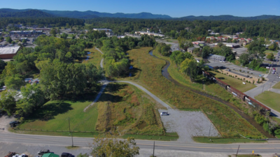
A North Carolina city has completed the first phase of a floodplain restoration project more than two decades after acquiring land vulnerable to flooding. The City of Hendersonville’s Lower Mud Creek Floodplain Restoration Project has transformed approximately 27 acres into restored wetlands, streams, natural floodplain habitat and public green space. According to the city’s October 27, 2026, announcement, the project is expected to provide additional floodwater storage and reduce risks for as many as 93 nearby properties with an assessed value of approximately $60 million. A ribbon-cutting ceremony is scheduled for October 30 to mark the completion of Phase 1.
Why Hendersonville acquired the land in 2002
The project centres on two city-owned properties along Mud Creek in the southside of Hendersonville, North Carolina. The city acquired the land in 2002 partly to preserve floodwater storage and prevent further development in an area vulnerable to flooding. Mud Creek has a long history of flooding. During the 19th and early 20th centuries, sections of the creek were straightened, dredged and separated from surrounding land by raised embankments, known as berms. These interventions were intended to drain the valley and make more land available for agriculture and development.Over time, commercial construction, filling of floodplain areas and changes to the stream system reduced the landscape’s natural ability to hold floodwater. The creek also became disconnected from parts of its floodplain, limiting the space available for water to spread during heavy rainfall. The restoration project seeks to reverse some of these changes by reconnecting the creek and its tributaries to the surrounding floodplain, allowing the landscape to perform its natural flood-management function.
How the 27-acre restoration project works
The project includes approximately 2,300 linear feet of tributary stream restoration and 1,500 linear feet of channel restoration along Mud Creek. It also involves restoring 8.5 acres of wetlands and restoring or enhancing approximately 9.2 acres of riparian floodplain, the areas alongside streams and waterways. These measures are designed to create more room for water during storms. The restored wetlands can collect and gradually release stormwater during smaller rainfall events, while the broader floodplain provides additional space for water to spread during larger floods.The project also incorporates water-control structures and native vegetation to support the restored landscape. Pedestrian bridges, approximately 2,500 linear feet of paved greenway and 1,600 linear feet of natural-surface trail are intended to make the site accessible to the public. The combination of flood management, habitat restoration and recreational infrastructure means the site is intended to serve several purposes rather than functioning solely as a drainage project.
Up to 93 properties could benefit from additional flood storage
According to the city, the restored floodplain is expected to provide approximately 20 acre-feet of additional flood storage. One acre-foot represents enough water to cover one acre of land to a depth of one foot. The additional capacity is intended to help reduce flood risk for as many as 93 nearby properties, representing approximately $60 million in assessed value. The figure describes the assessed value of the properties potentially benefiting from reduced risk, rather than a guaranteed amount of financial savings or damage avoided.By giving floodwater more room to spread naturally, the project aims to reduce the pressure on nearby developed areas during heavy rainfall. The restoration is also expected to improve water quality by helping wetlands and vegetation filter runoff, while creating better habitat for aquatic life and other wildlife. However, the city’s announcement describes expected benefits. The additional storage does not mean flooding will be eliminated, particularly during severe weather events.
Funding and partnerships helped bring the project to completion
The restoration took years of watershed planning, environmental assessments, engineering, grant development and coordination among public agencies and technical partners. In spring 2023, Hendersonville received grant funding through the North Carolina Land and Water Fund and the North Carolina Division of Water Infrastructure to support the design and construction of Phase 1. The wider project has also received support from the North Carolina Water Resources Development Grant Program, the North Carolina Flood Resiliency Blueprint and the city.Wildlands Engineering served as the project engineer, while Shamrock Environmental was responsible for construction. Land of Sky Regional Council, EcoForesters and other technical and regulatory partners also contributed to the initiative. The city announced that the first phase would be formally marked with a ribbon-cutting ceremony on October 30, 2026, at 519 South Grove Street in Hendersonville.The Lower Mud Creek project illustrates how land acquired for flood protection can eventually support a broader environmental and community benefit. By restoring wetlands and reconnecting streams to their floodplain, Hendersonville is seeking to improve its resilience to flooding while creating natural habitat and accessible green space for residents.